Observaciones preliminares sobre flujos de lodo cuaternarios relacionados con la actividad del Volcán Nevado del Ruiz en la región de Armero-Guayabal-Mariquita (departamento del Tolima, Colombia) .
Fuente: http://www.bdigital.unal.edu.co/31455/
Mojica, Jairo and Brieva, Jorge and Villarroel, Carlos and Colmenares, Fabio and Moreno, Manuel (2012) Observaciones preliminares sobre flujos de lodo cuaternarios relacionados con la actividad del volcán nevado del ruiz en la región de armero-guayabal-mariquita (departamento del tolima, colombia). Geología Colombiana – An International Journal on Geosciences; Vol. 14 (1985); 141-164 Geología Colombiana; Vol. 14 (1985); 141-164 2357-3767 0072-0992 .
![[img]](https://i1.wp.com/www.bdigital.unal.edu.co/31455/1.hassmallThumbnailVersion/30627-110892-1-PB.pdf) | PDF 20MB |
URL oficial: http://revistas.unal.edu.co/index.php/geocol/artic…
Resumen
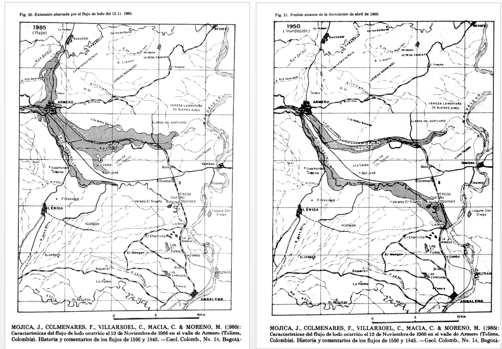
Con motivo de las erupciones ocurridas el 13 de noviembre de 1985 en el Volcán Nevado del Ruiz y los destrozos causados por los consecuentes “flujos de lodo” (en realidad flujos de escombros, o ”debris flows”) a lo largo de los cauces de los Ríos Lagunilla y Gualí, se emprendió un estudio regional para evaluar el riesgo geológico de las partes bajas del extremo nororiental del Departamento del Tolima (mitad occidental de la zona meridional del Valle Medio del Rio Magdalena). Los diferentes perfiles estratigráficos investigados señalan que los valles de los Rios Lagunilla y Recio, así como las planicies de Mariquita y Guayabal, constituyen conos de deyección (abanicos] formados en mayor proporción por efecto de flujos de lodo transportados por los ríos que descienden directamente del Volcán Nevado del Ruiz (Lagunilla, Recio y Gualí).Dichos flujos de lodo representan eventos catastróficos generados por repentinos desprendimientos y/ o fusión parcial de los glaciares de la vertiente oriental de la Cordillera Central, en el área correspondiente al Parque Nacional de los Nevados que incluye los Volcanes del Ruíz, Santa Isabel, El Cisne, Quindío y Tolima.Los resultados obtenidos del estudio de las propiedades generales de los sedimentos acumulados el 13 de Noviembre de 1985 en Armero y Mariquita han permitido identificar con certeza flujos anteriores que se caracterizan por: a) Su relativa alta cohesión, que da origen al desarrollo de taludes verticales. b) La mezcla caótica de materiales poligénicos de muy diversos tamaños. c) La combinación frecuente de clastos angulares (casi siempre predominantes) y subredondeados a redondeados . d) La pobre expresión de las estructuras primarias internas. Además de los flujos de lodo, en las columnas estratigráficas aparecen con frecuencia importantes espesores de sedimentos grises y deleznables, areno-conglomeráticos, depositados por aguas fluviales de mediana energía; se tienen también delgadas capas piroclásticas (ceniza y lapilli) que atestiguan anteriores explosiones de los volcanes de la Cordillera Central, no datadas hasta el momento.
.
With reference to the eruption of the Nevado del Ruiz Volcano on November 13, 1985, and the destruction caused by subsequent mudflows (debris flows s.e.) along the length of the banks of the Lagunilla and Gualí Rivers, a regional study has been undertaken in order to evaluate the geological risk for the lower parts of the extreme NE (NE end) of the Departamento del Tolima, Colombia (in the western half of the southern end of the Middle Magdalena Valley). The present study of the stratigraphic sections indicates that the Lagunilla and Recio river valleys, as well as the flatlands of Mariquita and Guayabal, are constituted by accumulations of succesive alluvial fans, which were formed, for the most part, as a result of mudflows along the riverbeds which descend directly from the Nevado del Ruiz volcano (Lagunilla, Recio and Gualí).Such mudflows represent catastrophic events generated by sudden slides and/or partial melting of the glaciers of the eastern slope of the Central Cordillera, in the area corresponding to the National Park of the Nevados which includes the Ruiz, Cisne, Santa Isabel, Quindío and Tolima volcanoes.The present study of the general sedimentological properties of the sediments accumulates on November 13, 1985 in Armero and Mariquita has allowed a clear identification of older mudflows in the region. These flows share the following characteristics: the chaotic mixture of polygenic materials of varied sizes; the frequent combination of angular clasts (almost always predominant) with subrounded to rounded clasts; and, finaly the poor expressión of their primary internal structures.In the stratigraphic columns there appear not only the mudflows, but frequently also important banks of gray sandy-conglomeratic sediments, which thin pyroclastic beds, constituted by ashes and lapilli, which testify the previous explosions of the volcanoes of this sector of the Central Cordillera. At the present time, these pyroclastic beds have not been dated.
.
Infolge von Schlammströmen entlang der Flüsse Lagunilla und Gualí am. 13.11.85 wurden die Städte Armero (vollständig) Mariquita und Honda (teilweise) zerstört, Anlässlich dieses Ereignisses hat man subregional Untersuchungen durchgeführt um das damit verbundene geologishe Risiko im nordöstlichen Teil des Departamento Tolima festzustellen.Die bearbeiteten stratigraphischen Profile weisen darauf hin, dass die Täler der Lagunilla und Recio Flüsse, sowie die Ebenen von Mariquita und Guayabal Schuttkegel darstellen, welche zum grossen Teil durch Schlammströme entlang der Flusse mit direkter Verbindung mit dem Ruiz Vulkan entstanden sind.Die genannten Schlammströme stellen Katastrophenartige Ereignisse dar, die auf Grund rascher Abstürze und/oder partieller Abschmelzung der Gletscher im östlichen Hang der Zentral Kordillere im Gebiet des “Parque Nacional de los Nevados”, wo die Vulkane Ruíz, Santa Isabel, El Cisne, Quindío und Tolima liegen, entstanden.Die Untersuchung der allgemeinen Markmale der am 13.11.85 in Armero und Mariquita abgelagerten Sedimente diente einer zuverlässigen Identifizierung von älteren Sachlammströmen. Diese sind gekennzeichnet durch:a) Relativ hohe Bindung der Komponenten, wodurch die Entwicklung vertikaler Wande verursacht wird.b) Inhomogene Mischungen von polymiktischen Materialien ganz unterschiedlicher Grösse.c) Die häufige Kombination eckiger (im allgemeinen), und abgerundeter Gerolle.d) Schlecht erkennbare intern-sinsedimentäre Strukturen.In den stratigraphischen Profilen findet man auch Abfolgen von mächtigen, gräulichen, lockeren, sandig bis konglomeratischen Sedimenten, die im wasserreichen Milieu abgesetzt wurden; geringmächtige pyroklastishe Schichten sind ebenfalls vorhanden, welche von älteren,undatierten Ausbrüchen der Vulkane im Bereich der Zentral-Kordillere zeugen.
MAPAS del documento:


—
Relacionados:
A LA MEMORIA DE ARMERO, 30 AÑOS DESPUÉS DE LA TRAGEDIA
EL DESASTRE DE ARMERO A LOS 30 AÑOS DE LA ERUPCIÓN DEL RUIZ
—
—


No hay comentarios:
Publicar un comentario